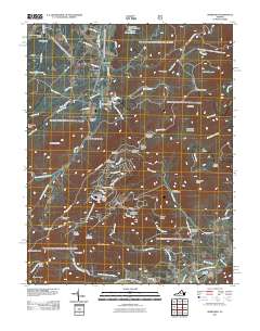
2011 Map of Sherando
USGS Topo · Published 2011About this map
Mount Torry Furnace stands as a significant landmark in this high-altitude landscape of Augusta County, situated at the base of Torry Mountain. This 2011 survey captures a region defined by its rugged topography and outdoor recreational sites, including Sherando Camp and the Maupin Field Shelter. The path of the Blue Ridge Pkwy winds through the center of the sheet, providing access to scenic vistas at Ravens Roost Overlook, Greenstone Overlook, and Rock Point Overlook.
Find a feature on this map
81 named features on this map. Tap any name to fly to it.
Don’t see what you’re looking for? This feature index may not catch every label — zoom into the map to look around manually.
Map Details
Editions of this 2011 Sherando Map
This is the sole edition of this map. No revisions or reprints were ever made.
Other maps of this area

1892 · Buckingham
USGS Topo · 1:125,000

1892 · Harrisonburg
USGS Topo · 1:125,000

1894 · Staunton
USGS Topo · 1:125,000

1894 · Lexington
USGS Topo · 1:125,000

1934 · Waynesboro
USGS Topo · 1:48,000

1936 · Vesuvius
USGS Topo · 1:48,000

1939 · Waynesboro
USGS Topo · 1:62,500

1941 · Vesuvius
USGS Topo · 1:62,500

1943 · Lovingston
USGS Topo · 1:62,500

1944 · Staunton
USGS Topo · 1:62,500