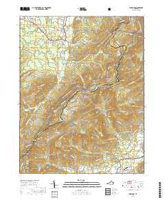
2019 Map of Sherando
USGS Topo · Published 2019About this map
Mount Torry Furnace stands as a focal point of industrial history in this high-altitude landscape where Augusta and Nelson counties meet. The terrain is defined by the winding Blue Ridge Pkwy and the Appalachian National Scenic Trail, which navigate a complex of ridges including Torry Ridge, Pine Ridge, and Grassy Ridge. This 2019 survey shows the modern recreational footprint of the George Washington National Forest, notably around the Wintergreen resort area and the nearby Rockfish Airpark.
Find a feature on this map
112 named features on this map. Tap any name to fly to it.
Don’t see what you’re looking for? This feature index may not catch every label — zoom into the map to look around manually.
Map Details
Editions of this 2019 Sherando Map
This is the sole edition of this map. No revisions or reprints were ever made.
Other maps of this area

1892 · Buckingham
USGS Topo · 1:125,000

1892 · Harrisonburg
USGS Topo · 1:125,000

1894 · Staunton
USGS Topo · 1:125,000

1894 · Lexington
USGS Topo · 1:125,000

1934 · Waynesboro
USGS Topo · 1:48,000

1936 · Vesuvius
USGS Topo · 1:48,000

1939 · Waynesboro
USGS Topo · 1:62,500

1941 · Vesuvius
USGS Topo · 1:62,500

1943 · Lovingston
USGS Topo · 1:62,500

1944 · Staunton
USGS Topo · 1:62,500