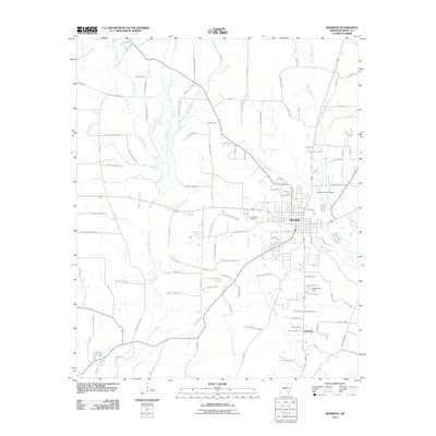
2011 Map of Sheridan
USGS Topo · Published 2011About this map
The Grant County seat of Sheridan serves as the central hub of this 2011 survey, showing a landscape defined by its creek systems and forestry infrastructure. The town is situated at the confluence of several waterways, including Town Branch and Deer Creek, which flow through the residential grid toward larger bodies like Lake Brown. To the north and west, the terrain transitions into a dense network of timber-management routes such as Forestry Road 9600 and Forestry Road 9605, which crisscross the drainage basins of Little Lost Creek and Lost Creek.
Find a feature on this map
107 named features on this map. Tap any name to fly to it.
Don’t see what you’re looking for? This feature index may not catch every label — zoom into the map to look around manually.
Map Details
Editions of this 2011 Sheridan Map
This is the sole edition of this map. No revisions or reprints were ever made.
Other maps of this area

1955 · Little Rock
USGS Topo · 1:250,000

1956 · Little Rock
USGS Topo · 1:250,000

1960 · Little Rock
USGS Topo · 1:250,000

1963 · Prattsville
USGS Topo · 1:24,000
1963 · Tull
USGS Topo · 1:24,000

1964 · Little Rock
USGS Topo · 1:250,000

1964 · Sheridan
USGS Topo · 1:24,000

1964 · Cane Creek
USGS Topo · 1:24,000

1964 · Belfast
USGS Topo · 1:24,000
1964 · Millerville
USGS Topo · 1:24,000