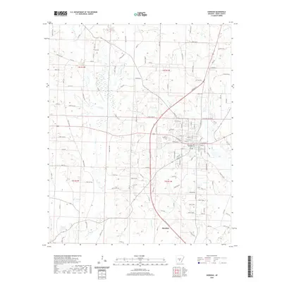
2020 Map of Sheridan
USGS Topo · Published 2020About this map
Sheridan serves as the focal point of this Grant County survey, centered around the Grant County Courthouse and the local Po. The town’s layout follows a grid that transitions into a network of forest roads and county routes, including Co Rd 573 and Co Rd 710. The landscape is defined by the complex drainage of the Saline River basin, featuring the meandering paths of Lost Cr, Little Lost Cr, and W Fork Big Cr.
Find a feature on this map
134 named features on this map. Tap any name to fly to it.
Don’t see what you’re looking for? This feature index may not catch every label — zoom into the map to look around manually.
Map Details
Editions of this 2020 Sheridan Map
This is the sole edition of this map. No revisions or reprints were ever made.
Other maps of this area

1955 · Little Rock
USGS Topo · 1:250,000

1956 · Little Rock
USGS Topo · 1:250,000

1960 · Little Rock
USGS Topo · 1:250,000

1963 · Prattsville
USGS Topo · 1:24,000
1963 · Tull
USGS Topo · 1:24,000

1964 · Little Rock
USGS Topo · 1:250,000

1964 · Sheridan
USGS Topo · 1:24,000

1964 · Cane Creek
USGS Topo · 1:24,000

1964 · Belfast
USGS Topo · 1:24,000
1964 · Millerville
USGS Topo · 1:24,000