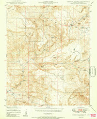
1950 Map of Sheridan Mountain
USGS Topo · Published 1950About this map
Prescott National Forest dominates this mid-century landscape in Yavapai County, where a network of cattle ranches and remote cabins defines the human footprint. High mesa country, including South Mesa and Cedar Mesa, is dissected by deep drainages like Cottonwood Canyon and Moonshine Canyon. The map documents a rugged livestock economy through established sites such as Spider Ranch, Dumbbell Ranch, and the Bar U Bar Ranch.
Find a feature on this map
69 named features on this map. Tap any name to fly to it.
Don’t see what you’re looking for? This feature index may not catch every label — zoom into the map to look around manually.
Map Details
Editions of this 1950 Sheridan Mountain Map
2 editions found
Other maps of this area

1887 · Prescott
USGS Topo · 1:250,000

1892 · Prescott
USGS Topo · 1:250,000

1903 · Congress
USGS Topo · 1:125,000

1904 · Congress
USGS Topo · 1:125,000

1923 · Signal
USGS Topo · 1:250,000

1942 · Signal
USGS Topo · 1:250,000

1945 · Bagdad
USGS Topo · 1:62,500

1947 · Simmons
USGS Topo · 1:62,500

1947 · Iron Springs
USGS Topo · 1:62,500

1947 · Kirkland
USGS Topo · 1:62,500