
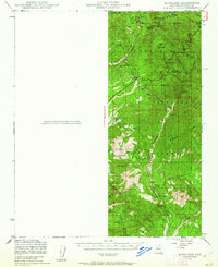
1947 Map of Kirkland
USGS Topo · Published 1959About this map
Prescott National Forest dominates this topographic survey of central Arizona, revealing a rugged landscape defined by deep canyons and scattered ranching outposts. Recorded in the late 1940s, the terrain is deeply etched by watercourses such as the Hassayampa River and Copper Basin Wash. Mining activity is a visible component of the regional economy, with the Climax Mine located near Quartz Mtn and the Die Rebel Mine situated south of Moores Spr. Human settlement is concentrated in small pockets like Wilhoit and Walnut Grove, where the local Walnut Grove School and a nearby Cem reflect the infrastructure of a rural community. Significant cattle operations are identified through property labels including the T K Bar Ranch, Carter Ranch, and Whitehead Ranch. The network of springs, such as Government Sprs and Board Cr Spr, highlights the critical role of water sources for both livestock and mining in this arid environment.
Find a feature on this map
38 named features on this map. Tap any name to fly to it.
Don’t see what you’re looking for? This feature index may not catch every label — zoom into the map to look around manually.
Map Details
Editions of this 1947 Kirkland Map
2 editions found
Other maps of this area

1887 · Prescott
USGS Topo · 1:250,000

1892 · Prescott
USGS Topo · 1:250,000

1903 · Bradshaw Mountains
USGS Topo · 1:125,000

1903 · Congress
USGS Topo · 1:125,000

1904 · Congress
USGS Topo · 1:125,000

1905 · Jerome
USGS Topo · 1:125,000

1947 · Crown King
USGS Topo · 1:62,500

1947 · Iron Springs
USGS Topo · 1:62,500

1947 · Mt. Union
USGS Topo · 1:62,500

1947 · Prescott
USGS Topo · 1:62,500