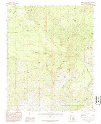
1986 Map of Sheridan Mountain
USGS Topo · Published 1986About this map
Prescott National Forest encompasses this high-elevation landscape in the mid-1980s, characterized by a complex network of canyons and mesas used for cattle ranching and resource management. The terrain is defined by the massive Cedar Mesa and the prominent Sheridan Mountain, while the hydrology of the area is supported by a high density of named water sources like Moonshine Springs, Alligator Spring, and Metote Tank. This map documents a transitional period for Arizona's backcountry, where established landmarks such as B T Butte and the Connell Mts overlook a series of modern stock-management features. Local history is etched into the landscape through descriptive place names such as Oregano Basin and Loco Creek, which reflect the early ranching era and the specific flora and experiences of the people who worked these canyons. The presence of Sheridan Lake and various tanks indicates the critical importance of water infrastructure in this arid forest environment.
Find a feature on this map
37 named features on this map. Tap any name to fly to it.
Don’t see what you’re looking for? This feature index may not catch every label — zoom into the map to look around manually.
Map Details
Editions of this 1986 Sheridan Mountain Map
This is the sole edition of this map. No revisions or reprints were ever made.
Other maps of this area

1887 · Prescott
USGS Topo · 1:250,000

1892 · Prescott
USGS Topo · 1:250,000

1923 · Signal
USGS Topo · 1:250,000

1942 · Signal
USGS Topo · 1:250,000

1945 · Bagdad
USGS Topo · 1:62,500

1947 · Sheridan Mountain
USGS Topo · 1:62,500

1947 · Camp Wood
USGS Topo · 1:62,500

1948 · Sheridan Mountain
USGS Topo · 1:63,360

1948 · Camp Wood
USGS Topo · 1:63,360

1948 · Bagdad
USGS Topo · 1:62,500