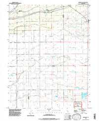
1992 Map of Sheridan
USGS Topo · Published 1997About this map
Sheridan anchors the eastern edge of this Central Valley landscape, situated just south of the Bear River where it forms the border between Placer and Yuba counties. The terrain is defined by an intricate network of drainage and water management, including the Yankee Slough, Coon Creek, and several siphons and aqueducts that crisscross the agricultural floor. To the south, the Mc Clellan Air Force Base Lincoln Communications Annex stands as a distinct institutional footprint amidst the rural sections and section lines. The map reveals the deep history of land division in the region, prominently featuring the Johnson Rancho and the complex system of levees protecting the low-lying plains. Local transit is marked by routes like Betz Road and Kempton Road, which serve the scattered farmsteads and agricultural plots that characterize this corner of the valley in the early 1990s.
Find a feature on this map
23 named features on this map. Tap any name to fly to it.
Don’t see what you’re looking for? This feature index may not catch every label — zoom into the map to look around manually.
Map Details
Editions of this 1992 Sheridan Map
This is the sole edition of this map. No revisions or reprints were ever made.
Other maps of this area

1888 · Marysville
USGS Topo · 1:125,000

1888 · Smartsville
USGS Topo · 1:125,000

1891 · Sacramento
USGS Topo · 1:125,000

1891 · Marysville
USGS Topo · 1:125,000

1891 · Smartsville
USGS Topo · 1:125,000

1892 · Sacramento
USGS Topo · 1:125,000

1892 · Smartsville
USGS Topo · 1:125,000

1893 · Sacramento
USGS Topo · 1:125,000

1894 · Smartsville
USGS Topo · 1:125,000

1894 · Marysville
USGS Topo · 1:125,000