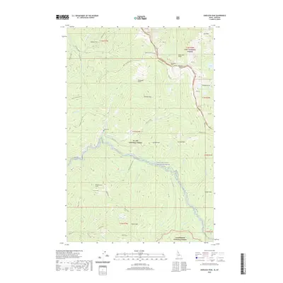
2020 Map of Sherlock Peak
USGS Topo · Published 2020About this map
The Bitterroot Range forms a natural border between Idaho and Montana, a high-altitude landscape defined by steep drainages and glacial features. In this recent survey of the North Idaho wilderness, the Saint Joe Wild and Scenic River carves through the heart of the St Joe National Forest, joined by numerous tributaries like Neversweat Cr and Sherlock Cr. The map reveals the isolation of the high country where human impact is sparse, most notably marked by the Heller Grave located near the headwaters. High peaks such as Sherlock Peak and Binocular Peak overlook a system of alpine waters including St Joe Lake and the Bonanza Lakes. The northern reaches are characterized by the Heller Simmons Divide and the Simmons Meadow, while the southern terrain is dominated by the Bean Divide and the remote Yankee Peak.
Find a feature on this map
55 named features on this map. Tap any name to fly to it.
Don’t see what you’re looking for? This feature index may not catch every label — zoom into the map to look around manually.
Map Details
Editions of this 2020 Sherlock Peak Map
This is the sole edition of this map. No revisions or reprints were ever made.
Other maps of this area

1911 · Lolo
USGS Topo · 1:250,000

1913 · Lolo
USGS Topo · 1:250,000

1918 · St Regis
USGS Topo · 1:125,000

1919 · St. Regis
USGS Topo · 1:125,000

1956 · Wallace
USGS Topo · 1:250,000

1956 · Hamilton
USGS Topo · 1:250,000

1957 · Illinois Peak
USGS Topo · 1:62,500

1957 · Simmons Peak
USGS Topo · 1:62,500

1959 · Hamilton
USGS Topo · 1:250,000

1960 · Wallace
USGS Topo · 1:250,000