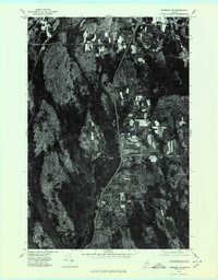
1975 Map of Sherman SW
USGS Topo · Published 1980About this map
The agricultural and timber lands of southern Aroostook and northern Penobscot County are captured here in the mid-1970s. The settlement of Benedicta serves as a central landmark, situated within a patchwork of cleared fields and dense woods that characterize this portion of Maine. Further north, the communities of Sherman and Sherman Mills highlight the historical importance of the region's milling and farming industry. The landscape is defined by its water systems, including the winding course of Salmon Stream and the dark waters of Plunkett Pond. This orthophoto provides a precise visual record of land use and forest cover during a period of modern rural development, showing the relationship between small-town centers like Stacyville and the surrounding wilderness. Researchers can observe the exact footprint of farmsteads and rural roads before the further expansion of regional infrastructure.
Find a feature on this map
7 named features on this map. Tap any name to fly to it.
Don’t see what you’re looking for? This feature index may not catch every label — zoom into the map to look around manually.
Map Details
Editions of this 1975 Sherman SW Map
This is the sole edition of this map. No revisions or reprints were ever made.
Other maps of this area

1940 · Sherman
USGS Topo · 1:62,500

1940 · Mattawamkeag
USGS Topo · 1:62,500

1942 · Mattawamkeag
USGS Topo · 1:62,500

1942 · Sherman
USGS Topo · 1:62,500

1951 · Millinocket
USGS Topo · 1:62,500

1953 · Stacyville
USGS Topo · 1:62,500

1954 · Millinocket
USGS Topo · 1:250,000

1958 · Millinocket
USGS Topo · 1:250,000

1960 · Millinocket
USGS Topo · 1:250,000
1975 · Sherman SE
USGS Topo · 1:24,000