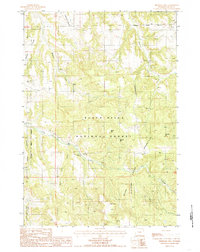
1984 Map of Sherrard Hill
USGS Topo · Published 1985About this map
Bear Lodge Mountains terrain dominates this 1980s topographic survey of Crook County, Wyoming. The landscape is defined by the high ridges of the Black Hills National Forest, where a network of watercourses including Lytle Creek and its tributary West Lytle Creek carve through the wooded uplands. Distinct peaks such as Sherrard Hill, Manly Hill, and Newton Hill provide prominent landmarks across the forest interior, while the western edge is marked by Nelson Canyon and the Brimmer and Whitetail areas. Infrastructure within this protected wilderness is sparse, limited primarily to a Radio Tower and the Wooden Pole Trans Line cutting across the north-central sections. This map documents the forest's drainage patterns and topographic character just before the mid-1980s, serving as a record of the primitive roads and natural features that define this portion of the Black Hills.
Find a feature on this map
16 named features on this map. Tap any name to fly to it.
Don’t see what you’re looking for? This feature index may not catch every label — zoom into the map to look around manually.
Map Details
Editions of this 1984 Sherrard Hill Map
This is the sole edition of this map. No revisions or reprints were ever made.
Other maps of this area

1898 · Sundance
USGS Topo · 1:125,000

1901 · Aladdin
USGS Topo · 1:125,000

1902 · Sundance
USGS Topo · 1:125,000

1903 · Aladdin
USGS Topo · 1:125,000

1905 · Devils Tower
USGS Topo · 1:125,000

1918 · Moorcroft
USGS Topo · 1:125,000

1954 · Sunny Divide
USGS Topo · 1:24,000

1954 · Storm Hill
USGS Topo · 1:24,000

1954 · Gillette
USGS Topo · 1:250,000

1955 · Devils Tower
USGS Topo · 1:62,500