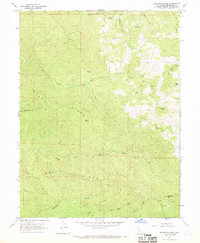
1967 Map of Sherwood Peak
USGS Topo · Published 1969About this map
Sherwood Peak rises above a landscape of high timbered ridges and deep drainage basins in the Mendocino mountains during the late 1960s. The area is defined by the headwaters of the South Fork Eel River and several branches of the Ten Mile River system, including the North Fork Ten Mile River, Middle Fork Ten Mile River, and South Fork Ten Mile River. The mapping shows a network of trails and jeep tracks connecting isolated clearings such as Ames Opening and Case Opening, which served as functional landmarks in this active logging and ranching region. To the east, Clarke Ranch and the settlement at Little Bear Haven represent the sparse human footprint within the complex topography of Bucha Ridge and Smith Ridge. Distinctive peaks like Strong Mtn and Brush Mtn provide vertical relief in a territory largely organized around river drainage and ridge-top access.
Find a feature on this map
27 named features on this map. Tap any name to fly to it.
Don’t see what you’re looking for? This feature index may not catch every label — zoom into the map to look around manually.
Map Details
Editions of this 1967 Sherwood Peak Map
2 editions found
Other maps of this area

1920 · Glenblair
USGS Topo · 1:62,500

1921 · Branscomb
USGS Topo · 1:62,500

1922 · Willits
USGS Topo · 1:62,500

1942 · Willits
USGS Topo · 1:62,500

1943 · Glenblair
USGS Topo · 1:62,500

1944 · Willits
USGS Topo · 1:62,500

1951 · Branscomb
USGS Topo · 1:62,500

1951 · Laytonville
USGS Topo · 1:62,500

1957 · Ukiah
USGS Topo · 1:250,000

1960 · Ukiah
USGS Topo · 1:250,000