
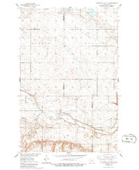
1950 Map of Sheyenne Lake NE
USGS Topo · Published 1950About this map
The Sheyenne River meanders across this rural landscape along the boundary of Sheridan Co and Wells Co, North Dakota. Mapped just after World War II, the sheet reveals a tightly knit prairie community organized around its local rural school districts and religious centers. Genealogists can identify the locations of the Mennonite Ch and Zion Cem, while the distribution of numerous educational sites, such as Fairview Sch No 1 and Berlin Sch No 2, illustrates the density of the farm population during this era. The topography transitions from the wetland-dotted plains near Sorenson Lake to the more pronounced relief of Pony Gulch, providing a detailed view of the Missouri River Basin development area before significant modern agricultural consolidation.
Find a feature on this map
13 named features on this map. Tap any name to fly to it.
Don’t see what you’re looking for? This feature index may not catch every label — zoom into the map to look around manually.
Map Details
Editions of this 1950 Sheyenne Lake NE Map
2 editions found
Other maps of this area

1940 · Aylmer
USGS Topo · 1:62,500

1941 · Selz
USGS Topo · 1:62,500

1945 · Manfred
USGS Topo · 1:62,500

1946 · Sheyenne Lake
USGS Topo · 1:48,000

1947 · Sheyenne Lake
USGS Topo · 1:62,500

1948 · Manfred
USGS Topo · 1:62,500

1949 · Manfred SW
USGS Topo · 1:24,000

1950 · Manfred NW
USGS Topo · 1:24,000

1950 · Sheyenne Lake
USGS Topo · 1:24,000

1950 · Manfred SW
USGS Topo · 1:24,000