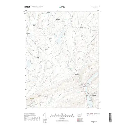
2019 Map of Shickshinny
USGS Topo · Published 2019About this map
The Susquehanna River carves a deep valley between Shickshinny Mtn and Penobscot Mtn at the southern edge of this Luzerne County landscape. The river-adjacent settlements of Shickshinny and Mocanaqua mark a transition from the industrial valley corridor to the upland plateaus of the north. This region is defined by a dense network of small family and community burial grounds, including the Benscoter Family Cem and Marvin Cem, which speak to the deep ancestral roots of the local townships. In the northwest, Huntington Mills and Harveyville sit along the banks of Huntington Cr, while Shickshinny Cr winds through the center of the sheet, feeding into Shickshinny Lake. The map details the interplay between the steep ridges of Huntington Mtn and the scattered rural hamlets like Bloomingdale and Muhlenburg that occupy the intervening hollows.
Find a feature on this map
147 named features on this map. Tap any name to fly to it.
Don’t see what you’re looking for? This feature index may not catch every label — zoom into the map to look around manually.
Map Details
Editions of this 2019 Shickshinny Map
This is the sole edition of this map. No revisions or reprints were ever made.
Other maps of this area

1891 · Harveys Lake
USGS Topo · 1:62,500

1893 · Harvey Lake
USGS Topo · 1:62,500

1894 · Shickshinny
USGS Topo · 1:62,500

1894 · Bloomsburg
USGS Topo · 1:62,500

1934 · Laporte
USGS Topo · 1:62,500

1946 · Sybertsville
USGS Topo · 1:31,680

1946 · Nanticoke
USGS Topo · 1:31,680

1946 · Shickshinny
USGS Topo · 1:31,680

1946 · Berwick
USGS Topo · 1:31,680

1946 · Harveys Lake
USGS Topo · 1:24,000
Featured Places
- Hunlock Township, PA
- Conyngham Township, PA
- Shickshinny, PA
- Mocanaqua, Conyngham Township
- Muhlenburg, Union Township