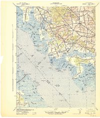
1941 Map of Shiloh
USGS Topo · Published 1941About this map
Cohansey River and the broad Delaware River define this coastal landscape, where the tides met a thriving agricultural and milling economy at the dawn of the 1940s. The map reveals an intricate network of drainage companies, such as the Silver Lake Meadow Company and Locust Meadow Company, which managed the low-lying marshes near Canton. Numerous mill sites, including Seventh Day Mill, Mickles Mills, and Sheppards Mill, are marked along the inland creeks, indicating the historical importance of water power to these rural communities. Along the shoreline, maritime infrastructure is visible through the Greenwich Pier and several navigational aids like Ship John Shoal Light. The social fabric of the era is evidenced by local landmarks like the County Almshouse and County Hospital near Shiloh, providing a detailed look at the infrastructure serving Cumberland and Salem Counties before mid-century modernization.
Find a feature on this map
135 named features on this map. Tap any name to fly to it.
Don’t see what you’re looking for? This feature index may not catch every label — zoom into the map to look around manually.
Map Details
Editions of this 1941 Shiloh Map
This is the sole edition of this map. No revisions or reprints were ever made.
Other maps of this area

1890 · Salem
USGS Topo · 1:62,500

1890 · Maurice Cove
USGS Topo · 1:62,500

1890 · Bay Side
USGS Topo · 1:62,500

1890 · Bridgeton
USGS Topo · 1:62,500

1890 · Glassboro
USGS Topo · 1:62,500

1891 · Maurice Cove
USGS Topo · 1:62,500

1894 · Bay Side
USGS Topo · 1:62,500

1894 · Bridgeton
USGS Topo · 1:62,500

1898 · Salem
USGS Topo · 1:62,500

1898 · Glassboro
USGS Topo · 1:62,500