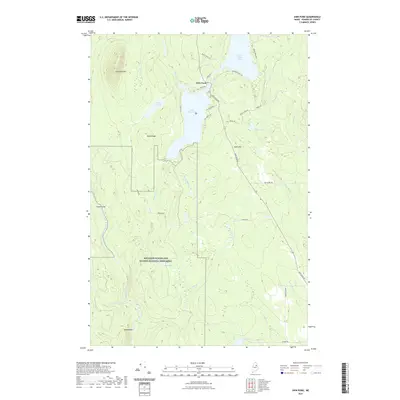
2021 Map of Shin Pond
USGS Topo · Published 2021About this map
Katahdin Woods and Waters National Monument dominates the southwestern quadrant of this Maine landscape, marking a protected wilderness where the Seboeis River and Moose Brook flow through a complex network of wetlands and peaks. The recreational heart of the area is centered on the settlement of Shin Pond, situated between Upper Shin Pond and Lower Shin Pond. This northern Penobscot County terrain is defined by dramatic elevation changes, ranging from the low-lying Gagnon Flat to the heights of Sugarloaf Mtn and Peaked Mtn. The map reveals a land structured by logging and access roads like Shin Pond Rd and Grondin Rd, which weave around numerous water bodies such as Ackley Pond and Davis Pond. The drainage patterns of Shin Brook and Sucker Brook illustrate the hydraulic connectivity that has historically supported the region's timber and outdoor heritage.
Find a feature on this map
40 named features on this map. Tap any name to fly to it.
Don’t see what you’re looking for? This feature index may not catch every label — zoom into the map to look around manually.
Map Details
Editions of this 2021 Shin Pond Map
This is the sole edition of this map. No revisions or reprints were ever made.
Other maps of this area

1940 · Island Falls
USGS Topo · 1:62,500

1940 · Sherman
USGS Topo · 1:62,500

1942 · Island Falls
USGS Topo · 1:62,500

1942 · Sherman
USGS Topo · 1:62,500

1953 · Stacyville
USGS Topo · 1:62,500

1954 · Shin Pond
USGS Topo · 1:62,500

1954 · Presque Isle
USGS Topo · 1:250,000

1954 · Millinocket
USGS Topo · 1:250,000

1958 · Presque Isle
USGS Topo · 1:250,000

1958 · Millinocket
USGS Topo · 1:250,000