
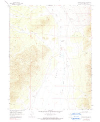
1969 Map of Shingle Pass SE
USGS Topo · Published 1971About this map
Cave Valley defines the central axis of this Lincoln County landscape, serving as a corridor for water and travel in the late 1960s. The ephemeral courses of Big Spring Wash and Cave Valley Wash indicate a high-desert environment where water management was critical for survival and land use. Isolated water sources such as Quartzite Spring and several named wells, including the Harris Well and the Cave Valley Seeding Well, point to the region's ranching or agricultural history.
Find a feature on this map
14 named features on this map. Tap any name to fly to it.
Don’t see what you’re looking for? This feature index may not catch every label — zoom into the map to look around manually.
Map Details
Editions of this 1969 Shingle Pass SE Map
2 editions found
Other maps of this area

1956 · Lund
USGS Topo · 1:250,000

1960 · Lund
USGS Topo · 1:250,000

1969 · Shingle Pass
USGS Topo · 1:24,000

1969 · Parker Station
USGS Topo · 1:24,000

1969 · Haggerty Spring
USGS Topo · 1:24,000

1971 · Sidehill Spring
USGS Topo · 1:24,000

1971 · Cave Valley Well
USGS Topo · 1:24,000
1973 · Dutch John Mtn
USGS Topo · 1:24,000
1978 · Mt. Grafton
USGS Topo · 1:24,000
1978 · Milk Ranch Spring
USGS Topo · 1:24,000