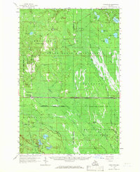
1958 Map of Shingleton
USGS Topo · Published 1966About this map
The Duluth South Shore and Atlantic railway cuts a sharp horizontal line through the heart of this Upper Peninsula landscape, connecting settlements like Shingleton and Creighton. This 1958 field-checked map reveals a region defined by extensive public lands and the legacy of the timber industry, with the Hiawatha National Forest and Manistique River State Forest covering much of the terrain. Small outposts and camps such as Cusino, Williams Crossing, and Hartman Camp are interspersed among a dense network of water bodies, including Cusino Lake, Sand Lake, and the winding Manistique River. Evidence of former industrial activity is visible in the Old Railroad Grade and Ishpeming and Superior routes, which likely served the logging operations that shaped these woods. The eastern edge of the map begins to transition into the Seney National Wildlife Refuge, marking a significant conservation boundary in the central Upper Peninsula.
Find a feature on this map
53 named features on this map. Tap any name to fly to it.
Don’t see what you’re looking for? This feature index may not catch every label — zoom into the map to look around manually.
Map Details
Editions of this 1958 Shingleton Map
3 editions found

Other maps of this area

1931 · Steuben NE
USGS Topo · 1:31,680

1931 · Shingleton SW
USGS Topo · 1:31,680

1931 · Steuben NW
USGS Topo · 1:31,680

1931 · Manistique River NW
USGS Topo · 1:31,680

1931 · Shingleton NE
USGS Topo · 1:31,680

1931 · Driggs Lake NW
USGS Topo · 1:31,680

1931 · Skeels Lake NE
USGS Topo · 1:31,680

1931 · Shingleton SE
USGS Topo · 1:31,680

1931 · Munising SE
USGS Topo · 1:31,680

1931 · Driggs Lake SW
USGS Topo · 1:31,680