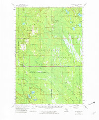
1958 Map of Shingleton
USGS Topo · Published 1982About this map
Shingleton sits at a critical junction of the Upper Peninsula’s mid-century timber and transport corridor, where the Duluth South Shore and Atlantic railroad cuts east-west across the landscape. This 1950s survey documents a region defined by extensive public lands, including the Munising State Forest and the Hiawatha National Forest. Small settlements like Melstrand and Williams Crossing are connected by a network of historic transportation routes, including an Old Railroad Grade and the Ishpeming and Superior road.
Find a feature on this map
56 named features on this map. Tap any name to fly to it.
Don’t see what you’re looking for? This feature index may not catch every label — zoom into the map to look around manually.
Map Details
Editions of this 1958 Shingleton Map
3 editions found

Other maps of this area

1931 · Steuben NE
USGS Topo · 1:31,680

1931 · Shingleton SW
USGS Topo · 1:31,680

1931 · Steuben NW
USGS Topo · 1:31,680

1931 · Manistique River NW
USGS Topo · 1:31,680

1931 · Shingleton NE
USGS Topo · 1:31,680

1931 · Driggs Lake NW
USGS Topo · 1:31,680

1931 · Skeels Lake NE
USGS Topo · 1:31,680

1931 · Shingleton SE
USGS Topo · 1:31,680

1931 · Munising SE
USGS Topo · 1:31,680

1931 · Driggs Lake SW
USGS Topo · 1:31,680