
1931 Map of Shingleton SE
USGS Topo · Published 1931About this map
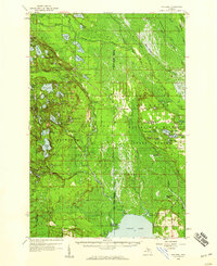
The Hiawatha National Forest dominates this 1931 survey of the Michigan Upper Peninsula, revealing a landscape defined by its wetlands and drainage networks. The eastern boundary of the forest sections off a wilderness area where numerous watercourses, including Commencement Creek, Pine Creek, and Star Creek, weave through the low-lying terrain. The human imprint on the land is concentrated along a distinct east-west corridor, where the Duluth South Shore and Atlantic railroad runs parallel to State Highway No 28. This infrastructure provides a clear link between the isolated stop at Creighton and the broader region. The presence of a prominent Transmission Line cutting across the sections further emphasizes the era's industrial expansion into the timber and bog lands of Schoolcraft County. This map captures the intricate hydrology of the Manistique River basin before modern development further altered the drainage patterns of these northern woods.
Find a feature on this map
15 named features on this map. Tap any name to fly to it.
Don’t see what you’re looking for? This feature index may not catch every label — zoom into the map to look around manually.
Map Details
Editions of this 1931 Shingleton SE Map
This is the sole edition of this map. No revisions or reprints were ever made.
Other maps of this area

1931 · Steuben NE
USGS Topo · 1:31,680

1931 · Shingleton SW
USGS Topo · 1:31,680

1931 · Steuben NW
USGS Topo · 1:31,680

1931 · Manistique River NW
USGS Topo · 1:31,680

1931 · Shingleton NE
USGS Topo · 1:31,680

1931 · Driggs Lake NW
USGS Topo · 1:31,680

1931 · Driggs Lake SW
USGS Topo · 1:31,680

1958 · Shingleton
USGS Topo · 1:62,500
1958 · Steuben
USGS Topo · 1:62,500

1958 · Marquette
USGS Topo · 1:250,000