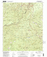
1997 Map of Shining Rock
USGS Topo · Published 2001About this map
Shining Rock Wilderness Area and the high ridges of the Pisgah National Forest dominate this landscape, showing a region managed for conservation and recreation in the late twentieth century. The terrain is defined by extreme elevation changes across peaks like Black Balsam Knob and Tennent Mountain, with drainage basins feeding the East Fork Pigeon River. Unlike the developed lowlands, this area preserves evidence of early industrial activity and resource management, including the Silvermine and a generic Mine site near the northern boundary.
Find a feature on this map
126 named features on this map. Tap any name to fly to it.
Don’t see what you’re looking for? This feature index may not catch every label — zoom into the map to look around manually.
Map Details
Editions of this 1997 Shining Rock Map
This is the sole edition of this map. No revisions or reprints were ever made.
Other maps of this area

1905 · Pisgah
USGS Topo · 1:125,000

1906 · Pisgah
USGS Topo · 1:125,000

1935 · Cruso
USGS Topo · 1:24,000

1935 · Brevard
USGS Topo · 1:24,000

1935 · Waynesville
USGS Topo · 1:24,000

1935 · Sam Knob
USGS Topo · 1:24,000

1935 · Rosman
USGS Topo · 1:24,000

1935 · Lake Toxaway
USGS Topo · 1:24,000

1935 · Shining Rock
USGS Topo · 1:24,000

1935 · Pisgah Forest
USGS Topo · 1:24,000