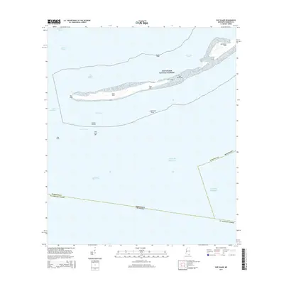
2015 Map of Ship Island
USGS Topo · Published 2015About this map
Ship Island serves as a vital natural barrier within the Gulf Islands National Seashore, separating the Mississippi Sound from the open Gulf of Mexico. This coastal survey highlights the island’s delicate geography, featuring landmarks such as West Point, West Head, and the narrow stretch known as The Neck. The map details the complex maritime environment surrounding the island, including the Gulfport Channel and Ship Island Pass, which have historically facilitated deep-water access for the region.
Find a feature on this map
26 named features on this map. Tap any name to fly to it.
Don’t see what you’re looking for? This feature index may not catch every label — zoom into the map to look around manually.
Map Details
Editions of this 2015 Ship Island Map
This is the sole edition of this map. No revisions or reprints were ever made.
Other maps of this area

1893 · Cat Island
USGS Topo · 1:62,500

1950 · Dog Keys Pass
USGS Topo · 1:24,000

1950 · Ship Island
USGS Topo · 1:24,000

1951 · Cat Island
USGS Topo · 1:24,000

1951 · Chandeleur Light
USGS Topo · 1:24,000

1953 · Mobile
USGS Topo · 1:250,000

1954 · Gulfport South
USGS Topo · 1:24,000

1954 · Deer Island
USGS Topo · 1:24,000

1954 · Biloxi
USGS Topo · 1:62,500

1957 · Mobile
USGS Topo · 1:250,000