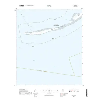
2020 Map of Ship Island
USGS Topo · Published 2020About this map
Ship Island stands as a narrow barrier between the Mississippi Sound and the open Gulf of Mexico, serving as a critical navigation marker for the region. This 2020 survey details the island's shifting topography within the Gulf Islands National Seashore, showing the distinct separation between West Head and the eastern portion terminated by Northwest Bluff. Navigation is the central theme of this coastal area, defined by the Gulfport Channel and the Ship Island Pass. The presence of a water-based Ferry route into Ship Island Harbor highlights the area's role as a recreational destination. Beneath the waterline, a complex network of shoals and channels like Walker Shoal, Loggerhead Shoal, and Middle Ground reveals the submarine landscape that has dictated maritime traffic for centuries along the Mississippi coast.
Find a feature on this map
26 named features on this map. Tap any name to fly to it.
Don’t see what you’re looking for? This feature index may not catch every label — zoom into the map to look around manually.
Map Details
Editions of this 2020 Ship Island Map
This is the sole edition of this map. No revisions or reprints were ever made.
Other maps of this area

1893 · Cat Island
USGS Topo · 1:62,500

1950 · Dog Keys Pass
USGS Topo · 1:24,000

1950 · Ship Island
USGS Topo · 1:24,000

1951 · Cat Island
USGS Topo · 1:24,000

1951 · Chandeleur Light
USGS Topo · 1:24,000

1953 · Mobile
USGS Topo · 1:250,000

1954 · Gulfport South
USGS Topo · 1:24,000

1954 · Deer Island
USGS Topo · 1:24,000

1954 · Biloxi
USGS Topo · 1:62,500

1957 · Mobile
USGS Topo · 1:250,000