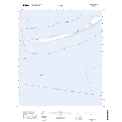
2024 Map of Ship Island
USGS Topo · Published 2024About this map
Ship Island dominates this maritime survey, a thin barrier island within the Gulf Islands National Seashore that separates the Mississippi Sound from the open Gulf of Mexico. The landform is characterized by its narrow, sandy stretches including The Neck and elevated points like Table Hill. Navigational features are prominent, with the Gulfport Channel and Ship Island Pass providing transit for vessels, while the Ferry Trl indicates the primary modern access point to the island's Ship Island Harbor. Submerged hazards such as Loggerhead Shoal, Middle Ground, and Walker Shoal define the shallow waters surrounding the island. This modern survey captures the island's dynamic geography, from the South East Spit to the Northwest Bluff, along the state boundary where Harrison County, Mississippi, meets St. Bernard Parish, Louisiana.
Find a feature on this map
27 named features on this map. Tap any name to fly to it.
Don’t see what you’re looking for? This feature index may not catch every label — zoom into the map to look around manually.
Map Details
Editions of this 2024 Ship Island Map
This is the sole edition of this map. No revisions or reprints were ever made.
Other maps of this area

1893 · Cat Island
USGS Topo · 1:62,500

1950 · Dog Keys Pass
USGS Topo · 1:24,000

1950 · Ship Island
USGS Topo · 1:24,000

1951 · Cat Island
USGS Topo · 1:24,000

1951 · Chandeleur Light
USGS Topo · 1:24,000

1953 · Mobile
USGS Topo · 1:250,000

1954 · Gulfport South
USGS Topo · 1:24,000

1954 · Deer Island
USGS Topo · 1:24,000

1954 · Biloxi
USGS Topo · 1:62,500

1957 · Mobile
USGS Topo · 1:250,000