
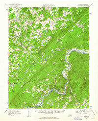
1961 Map of Shipman
USGS Topo · Published 1963About this map
Turner Mountain and Findlay Mountain dominate the central terrain of Nelson County, where the James River carves a winding path along the southeastern border. This 1960s landscape shows the transition from the high ridges of the Piney River Blue Ridge to the alluvial flats near Gladstone. The rail-dependent economy of the era is evident in the parallel routes of the Southern and Chesapeake and Ohio railroads, which linked small rural hubs like Shipman, Arrington, and Tye River.
Find a feature on this map
139 named features on this map. Tap any name to fly to it.
Don’t see what you’re looking for? This feature index may not catch every label — zoom into the map to look around manually.
Map Details
Editions of this 1961 Shipman Map
2 editions found
Other maps of this area

1892 · Lynchburg
USGS Topo · 1:125,000

1892 · Buckingham
USGS Topo · 1:125,000

1892 · Appomattox
USGS Topo · 1:125,000

1894 · Lexington
USGS Topo · 1:125,000

1929 · Covesville
USGS Topo · 1:62,500

1935 · Amherst
USGS Topo · 1:48,000

1935 · Covesville
USGS Topo · 1:62,500

1936 · Vesuvius
USGS Topo · 1:48,000

1939 · Amherst
USGS Topo · 1:62,500

1941 · Vesuvius
USGS Topo · 1:62,500