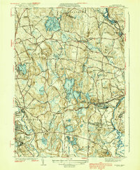
1939 Map of Shirley
USGS Topo · Published 1939About this map
The Nashua River and Squannacook River define the eastern edge of this region, which was surveyed in the 1920s and 1930s. The Boston and Maine Railroad serves as a vital corridor through the landscape, connecting the industrial and residential hubs of Leominster and Shirley. Between these larger settlements, smaller villages like Goodrichville and North Shirley appear alongside numerous water bodies, including Shirley Reservoir and Dickinson Reservoir.
Find a feature on this map
122 named features on this map. Tap any name to fly to it.
Don’t see what you’re looking for? This feature index may not catch every label — zoom into the map to look around manually.
Map Details
Editions of this 1939 Shirley Map
3 editions found
Other maps of this area

1885 · Worcester
USGS Topo · 1:62,500

1886 · Worcester
USGS Topo · 1:62,500

1887 · Marlboro
USGS Topo · 1:62,500

1887 · Fitchburg
USGS Topo · 1:62,500

1889 · Marlboro
USGS Topo · 1:62,500

1889 · Fitchburg
USGS Topo · 1:62,500

1892 · Worcester
USGS Topo · 1:62,500

1893 · Fitchburg
USGS Topo · 1:62,500

1893 · Groton
USGS Topo · 1:62,500

1896 · Marlboro
USGS Topo · 1:62,500