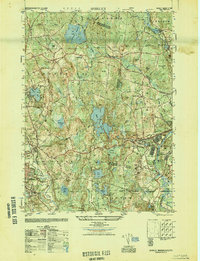
1949 Map of Shirley
USGS Topo · Published 1949About this map
The Fort Devens Military Reservation anchors the southeastern portion of this landscape, its grounds housing the Lovell Gen Hospital and the Sheridan Rifle Range during the late 1940s. The region is characterized by a dense network of glacial hills and water bodies, including the centrally located Shirley Reservoir and Massapoag Pond. Historical settlement patterns are visible in the distinct villages of Shirley Center, North Shirley, and Goodrichville, while the industrial and transport infrastructure is represented by the Boston and Maine Railroad corridors and an Abandoned Airfield near Lunenburg. The presence of the Industrial School and several sectarian burial grounds, such as the Shaker Cemetery and St Cecilia Cemetery, provides specific points of interest for genealogists tracing local families in the Middlesex and Worcester County borderlands.
Find a feature on this map
62 named features on this map. Tap any name to fly to it.
Don’t see what you’re looking for? This feature index may not catch every label — zoom into the map to look around manually.
Map Details
Editions of this 1949 Shirley Map
This is the sole edition of this map. No revisions or reprints were ever made.
Other maps of this area

1885 · Worcester
USGS Topo · 1:62,500

1886 · Worcester
USGS Topo · 1:62,500

1887 · Marlboro
USGS Topo · 1:62,500

1887 · Fitchburg
USGS Topo · 1:62,500

1889 · Marlboro
USGS Topo · 1:62,500

1889 · Fitchburg
USGS Topo · 1:62,500

1892 · Worcester
USGS Topo · 1:62,500

1893 · Fitchburg
USGS Topo · 1:62,500

1893 · Groton
USGS Topo · 1:62,500

1896 · Marlboro
USGS Topo · 1:62,500