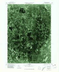
1975 Map of Shirley
USGS Topo · Published 1981About this map
The Nashua River winds through the southeastern reaches of this Worcester County landscape, defining the industrial and natural geography of the mid-1970s. This orthophotoquad provides an unvarnished aerial view of North Central Massachusetts, where the residential expansion of Lunenburg and the urban fringes of Leominster meet a patchwork of dense woodlands and significant water bodies. Notable landmarks like Whalom Lake and Hickory Hills Lake stand out clearly in the photographic grain, reflecting the region's long-standing reliance on its lakes and rivers for both recreation and industry. The convergence of the Squannacook River and the larger Nashua system near Shirley illustrates the classic New England pattern of river-valley settlement. Researchers can observe the mid-century road network as it begins to cut through the older agricultural and forested tracts, offering a precise visual record of the land before further modern development.
Find a feature on this map
8 named features on this map. Tap any name to fly to it.
Don’t see what you’re looking for? This feature index may not catch every label — zoom into the map to look around manually.
Map Details
Editions of this 1975 Shirley Map
This is the sole edition of this map. No revisions or reprints were ever made.
Other maps of this area

1885 · Worcester
USGS Topo · 1:62,500

1886 · Worcester
USGS Topo · 1:62,500

1887 · Marlboro
USGS Topo · 1:62,500

1887 · Fitchburg
USGS Topo · 1:62,500

1889 · Marlboro
USGS Topo · 1:62,500

1889 · Fitchburg
USGS Topo · 1:62,500

1892 · Worcester
USGS Topo · 1:62,500

1893 · Fitchburg
USGS Topo · 1:62,500

1893 · Groton
USGS Topo · 1:62,500

1896 · Marlboro
USGS Topo · 1:62,500