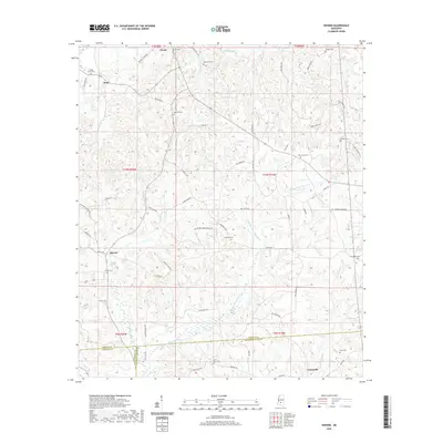
2020 Map of Shivers
USGS Topo · Published 2020About this map
Pinola and Shivers sit at the center of this rural Mississippi landscape, which is defined by the convergence of several county lines where Simpson Co, Lawrence Co, and Jefferson Davis Co meet. The terrain is intricately carved by a network of waterways, including the Strong River and Middle Prong Silver Cr. Numerous small family and community burial grounds, such as Westville Cem and Rose Hill Cem, are scattered throughout the region, offering significant value for genealogical research. The presence of Gwinville in the southern portion and various rural roads like Old Westville Rd and School House Rd suggest a long-established pattern of small-scale settlement and agriculture. This 2020 update provides a modern look at these traditional crossroads communities.
Find a feature on this map
75 named features on this map. Tap any name to fly to it.
Don’t see what you’re looking for? This feature index may not catch every label — zoom into the map to look around manually.
Map Details
Editions of this 2020 Shivers Map
This is the sole edition of this map. No revisions or reprints were ever made.
Other maps of this area

1953 · Hattiesburg
USGS Topo · 1:250,000

1953 · Natchez
USGS Topo · 1:250,000

1956 · Natchez
USGS Topo · 1:250,000

1958 · Hattiesburg
USGS Topo · 1:250,000

1959 · Natchez
USGS Topo · 1:250,000

1970 · Mendenhall East
USGS Topo · 1:24,000
1970 · Harrisville
USGS Topo · 1:24,000
1970 · Mendenhall West
USGS Topo · 1:24,000

1970 · New Hebron
USGS Topo · 1:24,000

1970 · Mount Carmel
USGS Topo · 1:24,000