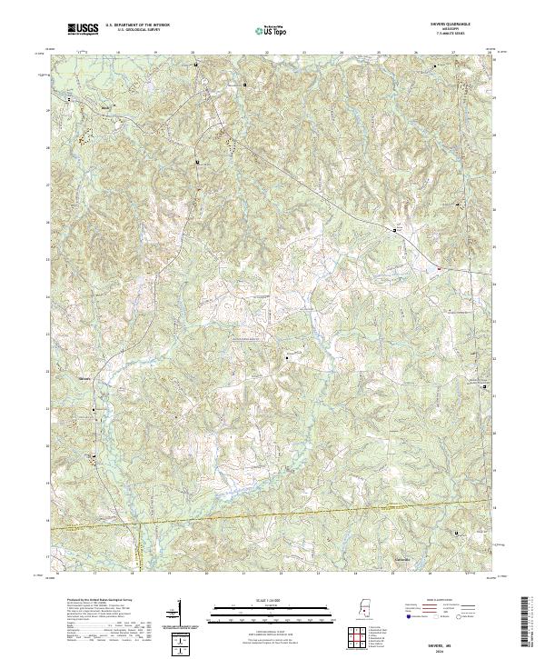
2024 Map of Shivers
USGS Topo · Published 2024About this map
Bush and Shivers sit within a landscape defined by the winding course of the Strong River and its numerous tributaries. This rural area in South Mississippi reflects a deep history of small-scale settlement and community organization, evidenced by the high concentration of family and community burial grounds such as Strong River Cem, Pinola Cem, and Rose Hill Cem. The terrain rises toward the Greater Dry Ridge in the east, where the Missionary Church Cem overlooks the drainage basins of the West Prong Silver Creek and Middle Prong Silver Creek.
Find a feature on this map
99 named features on this map. Tap any name to fly to it.
Don’t see what you’re looking for? This feature index may not catch every label — zoom into the map to look around manually.
Map Details
Editions of this 2024 Shivers Map
This is the sole edition of this map. No revisions or reprints were ever made.
Other maps of this area

1953 · Hattiesburg
USGS Topo · 1:250,000

1953 · Natchez
USGS Topo · 1:250,000

1956 · Natchez
USGS Topo · 1:250,000

1958 · Hattiesburg
USGS Topo · 1:250,000

1959 · Natchez
USGS Topo · 1:250,000

1970 · Mendenhall East
USGS Topo · 1:24,000
1970 · Harrisville
USGS Topo · 1:24,000
1970 · Mendenhall West
USGS Topo · 1:24,000

1970 · New Hebron
USGS Topo · 1:24,000

1970 · Mount Carmel
USGS Topo · 1:24,000