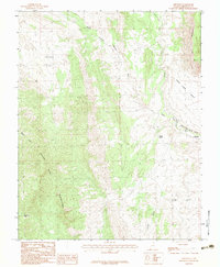
1983 Map of Shivwits
USGS Topo · Published 1983About this map
Shivwits sits at the eastern edge of this landscape, positioned along the vital corridor of the Santa Clara River and the Upper Santa Clara Bench Canal. The map illustrates the harsh, water-dependent geography of the region, where the Santa Clara Bench meets the towering Red Mountains and the Beaver Dam Mountains. Local history is anchored by the small Cem and isolated water sources like Pahcoon Spring and Camp Spring, which provided essential stops in an arid terrain. The map's detail also captures the transition from high canyon lands, such as Wittwer Canyon and Horse Canyon, to the more level expanse of Pahcoon Flat. These landmarks, along with Hell Hole Pass, define a rugged area where resource management and topography dictated the patterns of settlement and movement.
Find a feature on this map
16 named features on this map. Tap any name to fly to it.
Don’t see what you’re looking for? This feature index may not catch every label — zoom into the map to look around manually.
Map Details
Editions of this 1983 Shivwits Map
This is the sole edition of this map. No revisions or reprints were ever made.
Other maps of this area

1885 · St. George
USGS Topo · 1:250,000

1891 · St. George
USGS Topo · 1:250,000

1953 · Cedar City
USGS Topo · 1:250,000

1954 · Beaver Dam Mts NE
USGS Topo · 1:24,000

1954 · Gunlock
USGS Topo · 1:24,000

1954 · Beaver Dam Mts SE
USGS Topo · 1:24,000

1954 · St. George
USGS Topo · 1:62,500

1956 · St. George NW
USGS Topo · 1:24,000
1956 · St. George SW
USGS Topo · 1:24,000

1958 · Cedar City
USGS Topo · 1:250,000