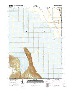
2017 Map of Shoalwater Bay
USGS Topo · Published 2017About this map
Upper Klamath Lake and its intricate northern shoreline dominate this 2017 study of the Klamath Basin. The landscape is defined by the transition from the open waters of Shoalwater Bay to the dense, protected environment of the Shoalwater Bay Marsh. To the north, the Williamson River feeds into the lake system, while the presence of the Modoc Point-Main Canal indicates the region's managed water network. High ground is represented by the prominent Eagle Ridge, which terminates at Eagle Point, and the isolated Bare Island rising from the lake.
Find a feature on this map
21 named features on this map. Tap any name to fly to it.
Don’t see what you’re looking for? This feature index may not catch every label — zoom into the map to look around manually.
Map Details
Editions of this 2017 Shoalwater Bay Map
This is the sole edition of this map. No revisions or reprints were ever made.
Other maps of this area

1889 · Klamath
USGS Topo · 1:250,000

1891 · Ashland
USGS Topo · 1:250,000

1893 · Ashland
USGS Topo · 1:250,000

1894 · Klamath
USGS Topo · 1:250,000

1897 · Ashland
USGS Topo · 1:250,000

1955 · Lake O' Woods
USGS Topo · 1:62,500

1955 · Pelican Butte
USGS Topo · 1:62,500

1955 · Klamath Falls
USGS Topo · 1:250,000

1955 · Medford
USGS Topo · 1:250,000

1957 · Medford
USGS Topo · 1:250,000