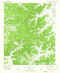
1972 Map of Shoemaker Canyon
USGS Topo · Published 1976About this map
The Zuni Indian Reservation dominates this 1970s landscape, where the deeply incised drainage systems of Shoemaker Canyon and Miller Canyon define the topography. In the southern portion of the map, the ancestral presence is marked at Ojo Pueblo (Ruins), situated near Ojo Pueblo Windmill. This terrain reflects a land management system reliant on scattered water sources, documented by family and agency landmarks such as Miller Well, COA No 1 Windmill, and RWPZ No 25 Windmill. The map also captures the political geography of the era, showing the Ramah Indian Reservation Boundary and the line separating Mc Kinley and Valencia counties. A network of jeep trails provides the primary access through the dissected hills, crossing seasonal watercourses like Hallado Draw and Pinitos Draw.
Find a feature on this map
16 named features on this map. Tap any name to fly to it.
Don’t see what you’re looking for? This feature index may not catch every label — zoom into the map to look around manually.
Map Details
Editions of this 1972 Shoemaker Canyon Map
This is the sole edition of this map. No revisions or reprints were ever made.
Other maps of this area

1886 · Wingate
USGS Topo · 1:250,000

1892 · Wingate
USGS Topo · 1:250,000

1954 · Saint Johns
USGS Topo · 1:250,000

1954 · Gallup
USGS Topo · 1:250,000

1957 · Saint Johns
USGS Topo · 1:250,000

1958 · Gallup
USGS Topo · 1:250,000

1958 · Saint Johns
USGS Topo · 1:250,000

1959 · Gallup
USGS Topo · 1:250,000

1962 · Gallup
USGS Topo · 1:250,000

1962 · Saint Johns
USGS Topo · 1:250,000