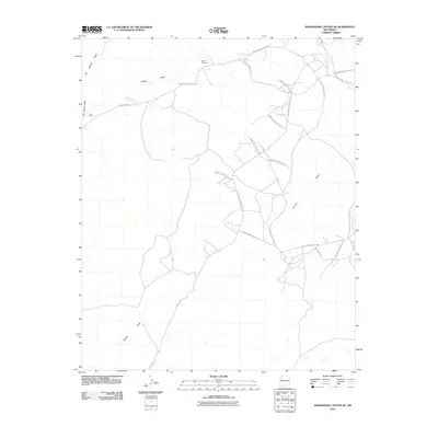
2010 Map of Shoemaker Canyon SE
USGS Topo · Published 2010About this map
Mares Cemetery serves as a small anchor for this desert landscape, where the seasonal drainage of Ojo Hallado Draw and Pinitos Draw defines the local topography. This 2010 survey shows a region largely characterized by the transition between localized ranching or settlement areas like Los Pinitos and the surrounding open rangeland. The infrastructure is primarily composed of a complex web of tribal and county routes, including County Rd 33 and numerous numbered corridors such as Indian Service Route 128. This network of roads indicates the vital connections maintained across the Eastern Navajo Agency. The presence of Terrero Draw and Pine Hill Rd suggest the seasonal nature of water and the importance of well-maintained access through the dry canyons and high ground.
Find a feature on this map
21 named features on this map. Tap any name to fly to it.
Don’t see what you’re looking for? This feature index may not catch every label — zoom into the map to look around manually.
Map Details
Editions of this 2010 Shoemaker Canyon SE Map
This is the sole edition of this map. No revisions or reprints were ever made.
Other maps of this area

1954 · Saint Johns
USGS Topo · 1:250,000

1957 · Saint Johns
USGS Topo · 1:250,000

1958 · Saint Johns
USGS Topo · 1:250,000

1962 · Saint Johns
USGS Topo · 1:250,000

1967 · Red Lake Mission
USGS Topo · 1:24,000

1967 · Chimney Hill
USGS Topo · 1:24,000
1967 · Nicoll Lake
USGS Topo · 1:24,000
1972 · Upper Galestina Canyon
USGS Topo · 1:24,000

1972 · Fence Lake
USGS Topo · 1:24,000
1972 · The Dyke
USGS Topo · 1:24,000