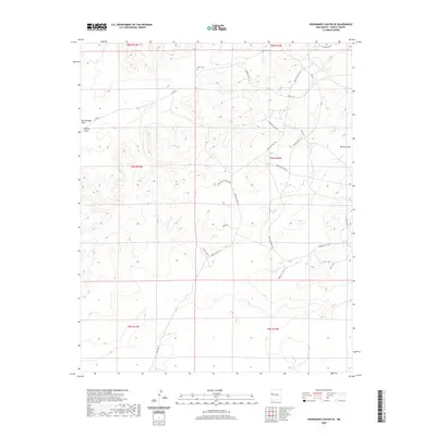
2020 Map of Shoemaker Canyon SE
USGS Topo · Published 2020About this map
Mares Cem serves as a quiet landmark in the northern reaches of this high-desert landscape within the Eastern Navajo Agency. This area is defined by a sparse but intricate network of Bureau of Indian Affairs and service roads, including Indian Svc Rte 131 and Indian Svc Rte 125, which navigate the various draws and mesas. Drainage patterns are clearly marked by Ojo Hallado Draw and Pinitos Draw to the west, while Terrero Draw cuts through the eastern portion of the quadrangle. The map reveals the modern infrastructure of the region, featuring named local routes like Pine Hill Rd and residential developments such as Hastings Loop. The cartography details the transition between various townships and ranges, providing a clear view of the land divisions and remote access points that characterize this part of New Mexico.
Find a feature on this map
29 named features on this map. Tap any name to fly to it.
Don’t see what you’re looking for? This feature index may not catch every label — zoom into the map to look around manually.
Map Details
Editions of this 2020 Shoemaker Canyon SE Map
This is the sole edition of this map. No revisions or reprints were ever made.
Other maps of this area

1954 · Saint Johns
USGS Topo · 1:250,000

1957 · Saint Johns
USGS Topo · 1:250,000

1958 · Saint Johns
USGS Topo · 1:250,000

1962 · Saint Johns
USGS Topo · 1:250,000

1967 · Red Lake Mission
USGS Topo · 1:24,000

1967 · Chimney Hill
USGS Topo · 1:24,000
1967 · Nicoll Lake
USGS Topo · 1:24,000
1972 · Upper Galestina Canyon
USGS Topo · 1:24,000

1972 · Fence Lake
USGS Topo · 1:24,000
1972 · The Dyke
USGS Topo · 1:24,000