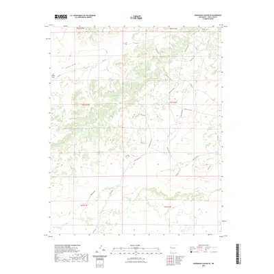
2023 Map of Shoemaker Canyon SE
USGS Topo · Published 2023About this map
Mares Cem sits within a landscape defined by high-elevation plateaus and deep arroyos in this 2023 survey of Cibola County. The terrain is marked by seasonal watercourses such as Pinitos Draw and Ojo Hallado Draw, reflecting the arid New Mexico environment. A dense network of service roads provides access across the rugged topography, including several Indian Service Routes and Bureau of Indian Affairs corridors. These roads, such as Indian Svc Rte 131 and BIA Rd 125, trace the natural contours of the land, connecting remote sections of the township and range system. The prominence of Terrero Draw in the south illustrates the drainage patterns essential to understanding the local geography and historical land use in this part of the Southwest.
Find a feature on this map
29 named features on this map. Tap any name to fly to it.
Don’t see what you’re looking for? This feature index may not catch every label — zoom into the map to look around manually.
Map Details
Editions of this 2023 Shoemaker Canyon SE Map
This is the sole edition of this map. No revisions or reprints were ever made.
Other maps of this area

1954 · Saint Johns
USGS Topo · 1:250,000

1957 · Saint Johns
USGS Topo · 1:250,000

1958 · Saint Johns
USGS Topo · 1:250,000

1962 · Saint Johns
USGS Topo · 1:250,000

1967 · Red Lake Mission
USGS Topo · 1:24,000

1967 · Chimney Hill
USGS Topo · 1:24,000
1967 · Nicoll Lake
USGS Topo · 1:24,000
1972 · Upper Galestina Canyon
USGS Topo · 1:24,000

1972 · Fence Lake
USGS Topo · 1:24,000
1972 · The Dyke
USGS Topo · 1:24,000