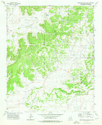
1972 Map of Shoemaker Canyon SE
USGS Topo · Published 1976About this map
Mares Cemetery and the nearby Las Norias Store sit in the northern reaches of this high-desert landscape, offering a glimpse into the localized commerce and community markers of the early 1970s. The terrain is defined by a series of drainage patterns, including the prominent Ojo Hallado Draw and Pinitos Draw, which cut through the mesa-dotted geography of New Mexico. The Ramah Indian Reservation Boundary runs through the central and eastern portions of the sheet, illustrating the intersection of sovereign tribal lands with the surrounding topography.
Find a feature on this map
8 named features on this map. Tap any name to fly to it.
Don’t see what you’re looking for? This feature index may not catch every label — zoom into the map to look around manually.
Map Details
Editions of this 1972 Shoemaker Canyon SE Map
This is the sole edition of this map. No revisions or reprints were ever made.
Other maps of this area

1954 · Saint Johns
USGS Topo · 1:250,000

1957 · Saint Johns
USGS Topo · 1:250,000

1958 · Saint Johns
USGS Topo · 1:250,000

1962 · Saint Johns
USGS Topo · 1:250,000

1967 · Red Lake Mission
USGS Topo · 1:24,000

1967 · Chimney Hill
USGS Topo · 1:24,000
1967 · Nicoll Lake
USGS Topo · 1:24,000
1972 · Upper Galestina Canyon
USGS Topo · 1:24,000

1972 · Fence Lake
USGS Topo · 1:24,000
1972 · The Dyke
USGS Topo · 1:24,000