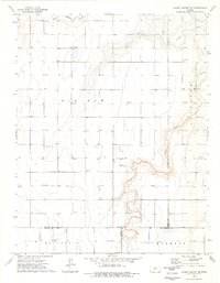
1974 Map of Shore Airport NE
USGS Topo · Published 1976About this map
The North Fork Cimarron River carves a distinct, winding path through the southwest Kansas plains, joined here by the Sand Arroyo Creek in a landscape defined by its agricultural and energy infrastructure. Surveyed in the early 1970s, the terrain across Big Bow and Sullivan is marked by an extensive grid of gas wells, illustrating the region's mid-century reliance on the Hugoton Gas Area. Rural life is anchored by local landmarks such as Bethel Ch and the Liverpool Cem, while small aviation sites like the Lucas Landing Strip point to the logistical needs of remote farming communities. The map also captures several county boundaries, where Stanton meets Stevens, Morton, and Grant counties, and identifies localized places including Congdon, Richfield, and Harmony that served as focal points for the surrounding farmsteads.
Find a feature on this map
19 named features on this map. Tap any name to fly to it.
Don’t see what you’re looking for? This feature index may not catch every label — zoom into the map to look around manually.
Map Details
Editions of this 1974 Shore Airport NE Map
This is the sole edition of this map. No revisions or reprints were ever made.
Other maps of this area

1891 · Larned
USGS Topo · 1:125,000

1900 · Syracuse
USGS Topo · 1:125,000

1900 · Lakin
USGS Topo · 1:125,000

1920 · Syracuse
USGS Topo · 1:125,000

1955 · Dodge City
USGS Topo · 1:250,000

1958 · Dodge City
USGS Topo · 1:250,000

1959 · Dodge City
USGS Topo · 1:250,000

1959 · Big Bow SW
USGS Topo · 1:24,000
1959 · Big Bow
USGS Topo · 1:24,000
1959 · Ulysses SW
USGS Topo · 1:24,000