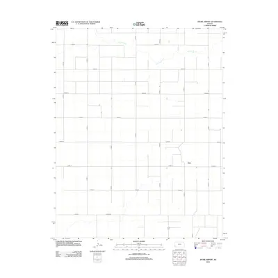
2012 Map of Shore Airport
USGS Topo · Published 2012About this map
Shore Airport sits at the heart of this grid-defined landscape in western Kansas, serving as a distinct focal point amidst the sprawling agricultural sections of Stanton County. The terrain is etched by the meandering path of Sand Arroyo Cr, which cuts across the northern and southeastern portions of the map, providing a natural contrast to the rigid geometry of the local road system. This network is defined by a series of lettered and numbered routes such as S Road L, E Road 20, and Co Road DD. The settlement pattern here reflects the vast scale of High Plains farming in the early 21st century, where large-scale land management is organized around these established section lines and occasional aviation facilities designed to support the rural economy.
Find a feature on this map
20 named features on this map. Tap any name to fly to it.
Don’t see what you’re looking for? This feature index may not catch every label — zoom into the map to look around manually.
Map Details
Editions of this 2012 Shore Airport Map
This is the sole edition of this map. No revisions or reprints were ever made.
Other maps of this area

1900 · Syracuse
USGS Topo · 1:125,000

1920 · Syracuse
USGS Topo · 1:125,000

1955 · Dodge City
USGS Topo · 1:250,000

1958 · Dodge City
USGS Topo · 1:250,000

1959 · Dodge City
USGS Topo · 1:250,000

1959 · Big Bow SW
USGS Topo · 1:24,000
1959 · Big Bow
USGS Topo · 1:24,000

1973 · Shore Airport SW
USGS Topo · 1:24,000

1973 · Shore Airport
USGS Topo · 1:24,000

1973 · Richfield NE
USGS Topo · 1:24,000