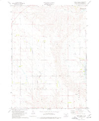
1974 Map of Short Creek
USGS Topo · Published 1977About this map
Fort Lookout stands near the banks of the Missouri River, overlooking the waters of Lake Francis Case in this mid-1970s survey. The landscape is defined by the sharp transition from the uplands of Lewis Hill down to the reservoir shoreline, where the Lower Brule Indian Reservation Boundary meets the townships of Fairland and Oacoma. Drainage patterns in this Lyman County region are carved by several prominent waterways, including Short Creek, De Smet Creek, and the North Fork American Crow Creek.
Find a feature on this map
13 named features on this map. Tap any name to fly to it.
Don’t see what you’re looking for? This feature index may not catch every label — zoom into the map to look around manually.
Map Details
Editions of this 1974 Short Creek Map
This is the sole edition of this map. No revisions or reprints were ever made.
Other maps of this area

1935 · Chamberlain
USGS Topo · 1:62,500

1939 · Chamberlain
USGS Topo · 1:62,500

1952 · Reliance SE
USGS Topo · 1:24,000

1952 · Oacoma
USGS Topo · 1:24,000

1953 · Huron
USGS Topo · 1:250,000

1954 · Huron
USGS Topo · 1:250,000

1955 · Mitchell
USGS Topo · 1:250,000

1959 · Mitchell
USGS Topo · 1:250,000

1966 · Big Bend Dam SE
USGS Topo · 1:24,000

1966 · Big Bend Dam
USGS Topo · 1:24,000