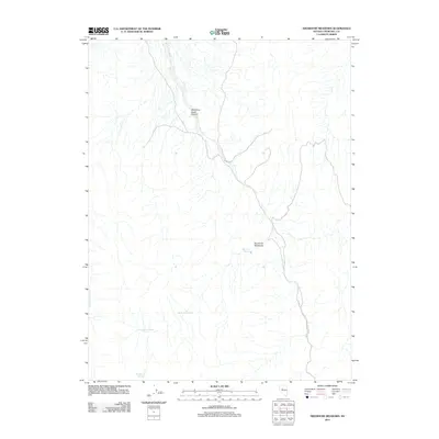
2011 Map of Shoshone Meadows
USGS Topo · Published 2011About this map
Shoshone Meadows serves as a vital focal point in this arid stretch of Churchill County, where scarce water sources dictate the placement of human and animal activity. The landscape is defined by the drainage of Shoshone Creek Canyon, a primary topographic feature that cuts through the terrain. In a region where reliable water is the most critical resource for ranching and survival, the map records a series of essential points including Shoshone Springs, Big Shoshone Spring, and Little Shoshone Spring. These specific coordinates provide insight into the historical grazing patterns and land use of Nevada's interior, showing how life clustered around these small, named seeps. Further west, Mud Spring Creek adds another layer to the hydrological network, illustrating the complex system of seasonal and permanent water that sustains this high-desert environment.
Find a feature on this map
7 named features on this map. Tap any name to fly to it.
Don’t see what you’re looking for? This feature index may not catch every label — zoom into the map to look around manually.
Map Details
Editions of this 2011 Shoshone Meadows Map
This is the sole edition of this map. No revisions or reprints were ever made.
Other maps of this area

1955 · Millett
USGS Topo · 1:250,000

1959 · Millett
USGS Topo · 1:250,000

1966 · Clan Alpine Ranch
USGS Topo · 1:62,500

1966 · Humboldt Salt Marsh
USGS Topo · 1:62,500

1966 · Shoshone Meadows
USGS Topo · 1:62,500

1966 · Edwards Creek Valley
USGS Topo · 1:62,500

1983 · Edwards Creek Valley
USGS Topo · 1:100,000
1990 · Hole In The Wall
USGS Topo · 1:24,000
1990 · Bernice Canyon
USGS Topo · 1:24,000
1990 · Byers Canyon
USGS Topo · 1:24,000