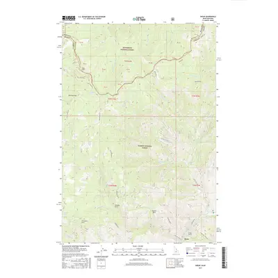
2017 Map of Shoup
USGS Topo · Published 2017About this map
The Salmon River corridor and the settlement of Shoup define this high-altitude landscape along the state line. In 2017, the map illustrates the transition between the Bitterroot National Forest to the north and the Salmon National Forest to the south. This is a region defined by complex drainage networks and steep-walled terrain, notably at Blue Nose and Sheepeater Point. The Divide NRT follows the crest of the mountains, tracing the border between Ravalli County, Montana, and Lemhi County, Idaho. For researchers of the local river economy or wilderness recreation, the map details numerous named drainages such as Boulder Cr, Spring Cr, and Horsefly Gulch. Historical land use is suggested by the presence of early national forest development roads like Nat For Dev Rd 038 and the riverside Salmon River Rd.
Find a feature on this map
32 named features on this map. Tap any name to fly to it.
Don’t see what you’re looking for? This feature index may not catch every label — zoom into the map to look around manually.
Map Details
Editions of this 2017 Shoup Map
This is the sole edition of this map. No revisions or reprints were ever made.
Other maps of this area

1956 · Elk City
USGS Topo · 1:250,000

1960 · Elk City
USGS Topo · 1:250,000

1960 · Painted Rocks Lake
USGS Topo · 1:62,500

1960 · Ulysses Mtn
USGS Topo · 1:62,500

1960 · Shoup
USGS Topo · 1:62,500

1960 · Piquett Mountain
USGS Topo · 1:62,500

1982 · Bighorn Crags
USGS Topo · 1:100,000

1991 · Horse Creek Pass
USGS Topo · 1:24,000
1991 · Tincup Hill
USGS Topo · 1:24,000
1991 · Henderson Ridge
USGS Topo · 1:24,000