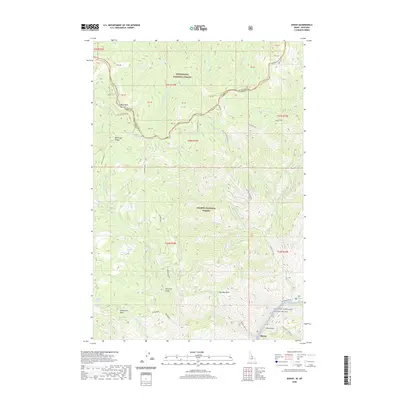
2020 Map of Shoup
USGS Topo · Published 2020About this map
Salmon National Forest and Bitterroot National Forest converge at the high-altitude boundary between Idaho and Montana. The terrain is defined by steep, drainage-carved ridges including Beartrap Ridge and significant vertical shifts down to the Salmon River corridor. Along the southern edge, the small settlement of Shoup sits near the confluence of McKay Cr and the river, marking a point of human activity in an otherwise wilderness-dominated landscape. The map illustrates a complex network of forest development roads, such as Nat For Dev Rd 044, which provide access to remote high points like Blue Nose. Evidence of the region’s rugged topography is found in labels like China Gulch and Horsefly Gulch, while the protected status of the waterway is noted through the Salmon Wild and Scenic River designation.
Find a feature on this map
50 named features on this map. Tap any name to fly to it.
Don’t see what you’re looking for? This feature index may not catch every label — zoom into the map to look around manually.
Map Details
Editions of this 2020 Shoup Map
This is the sole edition of this map. No revisions or reprints were ever made.
Other maps of this area

1956 · Elk City
USGS Topo · 1:250,000

1960 · Elk City
USGS Topo · 1:250,000

1960 · Painted Rocks Lake
USGS Topo · 1:62,500

1960 · Ulysses Mtn
USGS Topo · 1:62,500

1960 · Shoup
USGS Topo · 1:62,500

1960 · Piquett Mountain
USGS Topo · 1:62,500

1982 · Bighorn Crags
USGS Topo · 1:100,000

1991 · Horse Creek Pass
USGS Topo · 1:24,000
1991 · Tincup Hill
USGS Topo · 1:24,000
1991 · Henderson Ridge
USGS Topo · 1:24,000