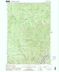
1991 Map of Shoup
USGS Topo · Published 1991About this map
The Salmon River cuts through the southern reaches of this mountain landscape, marking a corridor designated as a Wild and Scenic River Boundary. Along its banks, the small settlement of Shoup represents the primary human hub in a region otherwise dominated by the Bitterroot National Forest and Salmon National Forest. The map documents a history of resource extraction, with numerous labels for a Mine or Prospect scattered across the drainages of Spring Creek and Boulder Creek.
Find a feature on this map
32 named features on this map. Tap any name to fly to it.
Don’t see what you’re looking for? This feature index may not catch every label — zoom into the map to look around manually.
Map Details
Editions of this 1991 Shoup Map
This is the sole edition of this map. No revisions or reprints were ever made.
Other maps of this area

1956 · Elk City
USGS Topo · 1:250,000

1960 · Elk City
USGS Topo · 1:250,000

1960 · Painted Rocks Lake
USGS Topo · 1:62,500

1960 · Ulysses Mtn
USGS Topo · 1:62,500

1960 · Shoup
USGS Topo · 1:62,500

1960 · Piquett Mountain
USGS Topo · 1:62,500

1982 · Bighorn Crags
USGS Topo · 1:100,000

1991 · Horse Creek Pass
USGS Topo · 1:24,000
1991 · Tincup Hill
USGS Topo · 1:24,000
1991 · Henderson Ridge
USGS Topo · 1:24,000