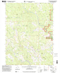
1997 Map of Showers Mountain
USGS Topo · Published 2001About this map
The Site of Fort Baker remains a significant historical anchor in this portion of the Six Rivers National Forest, where late 20th-century ranching and timber landscapes intersect. The terrain is characterized by high ridges like Gorden Ridge and Windy Ridge, with the Mad River carving through the center of the sheet. Scattered family holdings, including Stapp Ranch, Singleton Ranch, and Ackley Ranch, provide evidence of rural settlement patterns in the Humboldt highlands.
Find a feature on this map
62 named features on this map. Tap any name to fly to it.
Don’t see what you’re looking for? This feature index may not catch every label — zoom into the map to look around manually.
Map Details
Editions of this 1997 Showers Mountain Map
This is the sole edition of this map. No revisions or reprints were ever made.
Other maps of this area

1914 · Pilot Creek
USGS Topo · 1:62,500

1915 · Big Bar and Vicinity
USGS Topo · 1:250,000

1921 · Dyerville
USGS Topo · 1:62,500

1922 · Kneeland
USGS Topo · 1:62,500

1949 · Blocksburg
USGS Topo · 1:62,500

1949 · Weott
USGS Topo · 1:62,500

1950 · Iaqua Buttes
USGS Topo · 1:62,500

1951 · Weott
USGS Topo · 1:62,500

1951 · Blocksburg
USGS Topo · 1:62,500

1951 · Pilot Creek
USGS Topo · 1:62,500