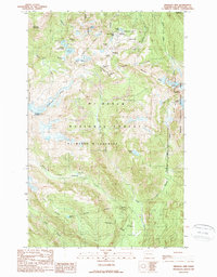
1989 Map of Shuksan Arm
USGS Topo · Published 1989About this map
Mount Baker Lodge stands as a central landmark in this high-altitude landscape of Whatcom County, situated near the headwaters of Bagley Creek and the shores of Picture Lake. The 1989 topography reveals a complex network of glacial features and alpine water bodies, including the White Salmon Glacier and Lower Curtis Glacier on the eastern slopes. The transition from Mt Baker National Forest to the Mt Baker Wilderness and North Cascades National Park is clearly delineated, marking a protected region dominated by peaks like Table Mountain and Barometer Mountain. Notable recreational and geological points of interest, such as Artist Point, the Galena Chain Lakes, and Baker Hot Spring, illustrate the intersection of early tourism infrastructure and the raw glacial environment of the Cascades during the late twentieth century.
Find a feature on this map
50 named features on this map. Tap any name to fly to it.
Don’t see what you’re looking for? This feature index may not catch every label — zoom into the map to look around manually.
Map Details
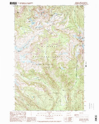
Editions of this 1989 Shuksan Arm Map
2 editions found
Other maps of this area

1909 · Mt Baker
USGS Topo · 1:192,000

1915 · Mt. Baker
USGS Topo · 1:250,000

1952 · Lake Shannon
USGS Topo · 1:62,500

1952 · Mt. Baker
USGS Topo · 1:62,500

1952 · Hamilton
USGS Topo · 1:62,500

1953 · Mt Shuksan
USGS Topo · 1:62,500

1955 · Concrete
USGS Topo · 1:250,000

1958 · Concrete
USGS Topo · 1:250,000

1962 · Concrete
USGS Topo · 1:250,000
1973 · Hamilton
USGS Topo · 1:62,500