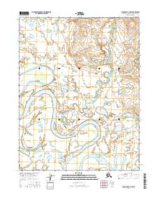
2016 Map of Shungnak D-3 NW
USGS Topo · Published 2016About this map
The Kobuk River dominates this Arctic landscape, its massive meanders and oxbow lakes carving a complex path through the Northwest Arctic Borough. This 2016 survey documents the intricate hydrologic network where the Shungnak River and Cosmos Creek converge toward the main river valley. The terrain is defined by a dense concentration of wetlands and unnamed water bodies that sit between the river's active channel and the surrounding tributaries. Local drainages like Garland Cr, Sheshok Cr, and the Black River feed into this system, illustrating a wilderness landscape shaped almost entirely by seasonal water movement and shifting alluvial deposits. The map captures the remote character of these township and range divisions, where few human landmarks exist outside of the essential natural waterways that historically serve as the primary corridors for travel in the region.
Find a feature on this map
14 named features on this map. Tap any name to fly to it.
Don’t see what you’re looking for? This feature index may not catch every label — zoom into the map to look around manually.
Map Details
Editions of this 2016 Shungnak D-3 NW Map
This is the sole edition of this map. No revisions or reprints were ever made.
Other maps of this area

1951 · Shungnak
USGS Topo · 1:250,000

1951 · Ambler River
USGS Topo · 1:250,000

1955 · Shungnak
USGS Topo · 1:250,000

1955 · Ambler River A-4
USGS Topo · 1:63,360

1955 · Shungnak D-4
USGS Topo · 1:63,360

1955 · Shungnak D-3
USGS Topo · 1:63,360

1956 · Ambler River
USGS Topo · 1:250,000

1964 · Shungnak
USGS Topo · 1:250,000

1964 · Ambler River
USGS Topo · 1:250,000
1966 · Ambler River A-4
USGS Topo · 1:63,360