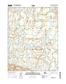
2016 Map of Shungnak D-4 NE
USGS Topo · Published 2016About this map
The Kobuk River dominates this northern Alaskan landscape, winding through a complex network of wetlands and tributary streams within the Northwest Arctic Borough. This 2016 survey by the U.S. Geological Survey captures a wild hydrologic system where the river’s oxbows and meanders shape the surrounding terrain. To the north, Pitkik Lake and Pitkik Cr feed into the primary waterway, while Kugachevik Cr and Little Black Cr drain the central and western reaches. The presence of the Black River in the southeast corner further illustrates the intricate water patterns of this subarctic environment. Lacking roads or permanent settlements, the map provides a detailed view of natural landforms and township boundaries, such as t18n r6e, essential for understanding the remote geography and land management divisions of this Arctic region.
Find a feature on this map
12 named features on this map. Tap any name to fly to it.
Don’t see what you’re looking for? This feature index may not catch every label — zoom into the map to look around manually.
Map Details
Editions of this 2016 Shungnak D-4 NE Map
This is the sole edition of this map. No revisions or reprints were ever made.
Other maps of this area

1951 · Shungnak
USGS Topo · 1:250,000

1951 · Ambler River
USGS Topo · 1:250,000

1955 · Shungnak
USGS Topo · 1:250,000

1955 · Ambler River A-4
USGS Topo · 1:63,360

1955 · Shungnak D-4
USGS Topo · 1:63,360

1955 · Shungnak D-3
USGS Topo · 1:63,360

1956 · Ambler River
USGS Topo · 1:250,000

1964 · Shungnak
USGS Topo · 1:250,000

1964 · Ambler River
USGS Topo · 1:250,000
1966 · Ambler River A-4
USGS Topo · 1:63,360