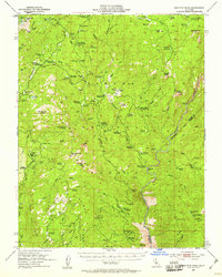
1953 Map of Shuteye Peak
USGS Topo · Published 1959About this map
Sierra National Forest lands dominate this mid-century survey, revealing a landscape defined by the logistics of the early 20th-century timber and ranching industries. Central Camp and Daulton Station stand out as hubs of activity within the High Sierra, supported by a network of summer cow camps and mountain meadows. The presence of the North McSwain Mine, McSwain Mine, and Strasbaugh Mine points to the area's mineral prospects, while the Future Farmers of America Camp indicates the region's evolving role in outdoor education and recreation.
Find a feature on this map
104 named features on this map. Tap any name to fly to it.
Don’t see what you’re looking for? This feature index may not catch every label — zoom into the map to look around manually.
Map Details
Editions of this 1953 Shuteye Peak Map
3 editions found

Other maps of this area

1897 · Yosemite
USGS Topo · 1:125,000

1900 · Yosemite
USGS Topo · 1:125,000

1901 · Mt. Lyell
USGS Topo · 1:125,000

1903 · Yosemite
USGS Topo · 1:125,000

1904 · Kaiser
USGS Topo · 1:125,000

1909 · Yosemite
USGS Topo · 1:125,000

1912 · Mariposa
USGS Topo · 1:125,000

1942 · Millerton Lake
USGS Topo · 1:62,500

1945 · Millerton Lake
USGS Topo · 1:62,500

1947 · Mariposa
USGS Topo · 1:250,000