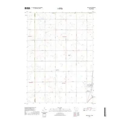
2018 Map of Sibley West
USGS Topo · Published 2018About this map
Sibley sits at the eastern edge of this landscape, serving as a hub for the surrounding agricultural community in the late 2010s. The terrain is defined by the Coteau des Prairies, an expansive upland plateau that influences the drainage patterns of the Little Rock River and several smaller streams like Otter Cr and Whitney Cr. The map reveals a structured grid of county roads and avenues that connect isolated homesteads and several significant local landmarks. For those researching family history, the map precisely identifies the Hope German Presbyterian Cem in the central township, alongside Saint Andrews Cem and Holman Cem near the town center. These sites, along with features like Argo Slough, provide specific points of reference for tracing rural development and legacy landholdings in Osceola County.
Find a feature on this map
45 named features on this map. Tap any name to fly to it.
Don’t see what you’re looking for? This feature index may not catch every label — zoom into the map to look around manually.
Map Details
Editions of this 2018 Sibley West Map
This is the sole edition of this map. No revisions or reprints were ever made.
Other maps of this area

1954 · Fairmont
USGS Topo · 1:250,000

1958 · Fairmont
USGS Topo · 1:250,000

1960 · Bigelow
USGS Topo · 1:24,000

1967 · Rushmore
USGS Topo · 1:24,000

1967 · Adrian SW
USGS Topo · 1:24,000

1972 · Ashton
USGS Topo · 1:24,000
1972 · Little Rock
USGS Topo · 1:24,000

1972 · Sibley West
USGS Topo · 1:24,000
1972 · George East
USGS Topo · 1:24,000

1972 · Cloverdale
USGS Topo · 1:24,000